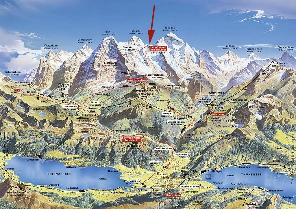
The Eiger
LocationMountain range: Bernese AlpsCountry: SwitzerlandCanton: Bern
Summit DataElevation: 3,967 meters (13,015 feet)Prominence: 362 meters (1,188 feet)Isolation: ~2.3 kilometers (1.4 miles) to Mönch
TopographyNorth face (Nordwand): vertical rise ~1,800 meters (5,900 feet) from the valley floorRidge lines: Mittellegigrat (east ridge), South Ridge (Südgrat), West RidgeTypical summit composition: metamorphic/igneous alpine rock, heavily glaciated approaches on higher ridges
Climbing Routes & DifficultyClassic routes: North Face (Himmelsleiter and Heckmair routes), Mittellegigrat, South RidgeDifficulty range: AD to ED+ on French adjectival scale depending on route and conditions; North Face ranges from ED- to ED+ and requires advanced alpine rock/ice/aid techniquesTechnical features: steep rock, sustained mixed climbing, long ice sections, rockfall and serac hazard on the North Face
Glaciation & SnowNearby glaciers: Eiger Glacier and North Face névés; glaciers on adjacent peaks influence approach and descentSeasonal snowpack: persistent at high elevations; objective hazard period typically late winter through spring and early summer for avalanche/icefall risk
AccessCommon base points: Interlaken, Grindelwald, Lauterbrunnen and Kleine ScheideggAccess infrastructure: mountain railway to Jungfraujoch and Kleine Scheidegg
Weather & Best SeasonBest climbing season: July to August for ridges and Fall or Spring for mixed alpine routesWeather hazards: rapid weather changes, high winds, whiteout, and temperature-driven rockfall
FacilitiesMountain huts: Mittellegihütte for east ridge; other huts and staffed facilities available in surrounding valleys and at Kleine ScheideggNearest settlements: Grindelwald, Lauterbrunnen, Wengen
Notable Records & History (brief)First ascent: East side via Mittellegigrat, 1858North Face first ascent: 1938 (Heckmair route), historically significant and often cited among the great north faces of the Alps
Suggested Additional Data (for profile use)GPS coordinates of summit: 46.5775° N, 8.0058° EFirst ascent parties and notable ascents (names/dates)Typical route grades and estimated timesSeasonal closure or local advisoriesCurrent condition sources (glacier/snow depth updates)